A Gustavus Conservation Lands Maps and Inventory

Conservation Lands Exhibit
Friday January 30th 5:00 – 7:00pm Reception
Gateway Gallery at Gustavus Community Center
A public presentation featuring maps and photos of the conservation lands within Gustavus. The maps are annotated to include text descriptions and conservation measures for each tract and related materials such as management plans and access information.
A live demonstration will show how to download a map of the Gustavus Beach Meadows onto your phone, along with the free Avenza map application, so you can track your progress while walking the conservation easement boundaries there in real time. The exhibit will stay up through January, so come visit and then make plans to explore our conservation lands in the New Year!
For the Beach Meadows Map:
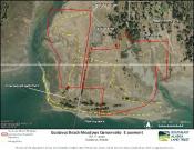
Using your phone:
1.Install the free version of Avenza on phone (App Store or Google Play)
2.Go to www.gustavus-ak.gov/bc-clac
3.Scroll to bottom right
5.Save to your phone the map.pdf at the bottom of the page
6.Use Avenza to open the map file
7.Navigate the boundaries as you walk!